Pisgah forest hikes cover more ground — literally and figuratively — than most visitors expect. Pisgah National Forest sprawls across over 500,000 acres of western North Carolina, divided into four ranger districts that stretch from the Tennessee border in the north all the way to Linville Gorge in the east and the Transylvania County waterfalls corridor in the south. It contains some of the highest peaks in the eastern United States, the birthplace of American forestry, two of the first designated wilderness areas east of the Rockies, dozens of named waterfalls, and hundreds of miles of maintained trails ranging from family-friendly creek walks to multi-day backcountry routes through genuine wilderness.
This guide covers the best Pisgah forest hikes organized by ranger district — because what you hike depends entirely on which corner of this massive forest you’re starting from. South near Brevard, the US-276 corridor puts you at Looking Glass Rock and a dozen waterfalls within an hour. North near Hot Springs, the Appalachian Ranger District puts you at Max Patch, the Laurel River Trail, and the AT corridor through Madison County. Each district is its own world.
Pisgah National Forest Hiking — At a Glance
Total acreage: 500,000+ acres across western NC
Ranger Districts: Pisgah (south), Appalachian/French Broad (north — Hot Springs), Appalachian/Toecane (northeast — Craggy Gardens, Roan), Grandfather (east — Linville Gorge)
Trails: Hundreds of miles across all districts — no single trail count
Permits required: None for hiking or backpacking
Dogs: Allowed on leash · few restrictions compared to national parks
Fee: Free to access · Some individual sites (Sliding Rock, Cradle of Forestry) charge day-use fees
Best season: Spring (wildflowers, high water) · Fall (foliage, clarity) · Winter (solitude, ice formations)
Hurricane Helene note: Some trails remain affected from September 2024 damage — confirm current status at fs.usda.gov before visiting
Nearest base for northern Pisgah hikes: Hot Springs NC — 15 min to Max Patch, 20 min to Lovers Leap AT trailhead
Pisgah National Forest — A Brief History Worth Knowing
Pisgah National Forest has a founding story that sets it apart from virtually every other national forest in the country. Founded in 1916, it was the first national forest east of the Mississippi created from purchased land rather than carved from the public domain. The land came largely from George Washington Vanderbilt II — the Biltmore Estate builder — whose widow sold nearly 100,000 acres to the federal government after his death. The name comes from Mount Pisgah on the Blue Ridge Parkway south of Asheville, itself named for the biblical mountain from which Moses first saw the Promised Land.
The forest is also the birthplace of American forestry. In 1898, German forester Carl Schenck opened the Biltmore Forest School on Vanderbilt’s land — the first school of forestry in the United States. Today the Cradle of Forestry heritage site on US-276 near Brevard preserves the original buildings, an old logging train engine, and three paved interpretive trails. It’s worth a stop for anyone spending time in the Pisgah Ranger District.
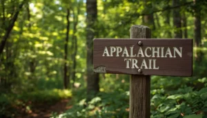
The forest also contains Shining Rock Wilderness and Linville Gorge — two of the first congressionally designated wilderness areas east of the Mississippi. And the Appalachian Trail runs through the northern Appalachian Ranger District from the Smokies through Max Patch and Hot Springs and north across the Roan Highland balds. When Earl Shaffer completed the first documented AT thru-hike in 1948, Pisgah National Forest rangers radioed his progress north from fire towers spaced across the district.
Hiking the northern Pisgah district? Windows Over Waterfalls is 15 minutes from Max Patch and 20 minutes from Hot Springs. Check Availability →
Pisgah Ranger District Hikes — South of Asheville (Brevard Area)
The Pisgah Ranger District is the most visited section of the forest — it sits between Asheville, Brevard, and Waynesville, and includes Looking Glass Rock, dozens of waterfalls, the Cradle of Forestry, Black Balsam Knob, and Shining Rock Wilderness. The US-276 corridor through this district is the single most waterfall-dense road in the state.
 The most iconic summit hike in Pisgah National Forest — and one of the most recognizable views in western NC. Looking Glass Rock is a white-granite pluton monolith rising to nearly 4,000 feet from the Davidson River valley floor. You’ve almost certainly seen it from the Blue Ridge Parkway without knowing it — the massive smooth rock face visible from Mt. Pisgah and Black Balsam is this one. The trail to the summit is a different experience than looking at it: a steady, switchbacking climb through rhododendron and hardwood forest with the views concealed until the final moments.
 At 6,214 feet, Black Balsam Knob is one of North Carolina’s forty mountains over 6,000 feet — and one of the most accessible of the group. The summit is reached via a short segment of the Art Loeb Trail, a 30.1-mile route that traverses Pisgah National Forest from Davidson River to Daniel Boone Boy Scout Camp. From the Black Balsam Road trailhead (a spur off the Blue Ridge Parkway near milepost 420.2), it’s less than a mile through balsam fir forest into an open, sun-drenched alpine meadow — one of the most New England-like landscapes in the southern Appalachians.
 One of the most visited and most unusual landscapes in all of Pisgah National Forest. Graveyard Fields sits in a mile-high valley on the Blue Ridge Parkway — a highland meadow ringed by 6,000-foot peaks, threaded by Yellowstone Prong, and named for the moss-covered tree stumps that resembled grave markers after a catastrophic windstorm toppled the original forest. A fire in 1925 burned the logged area, and the forest has been slow to recover at this elevation, leaving an open, otherworldly valley unlike anything else in the Pisgah district.
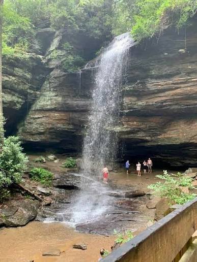
Exploring Pisgah’s northern district? Windows Over Waterfalls is your base camp — private waterfalls, 15 min from Max Patch. Book Direct →
Appalachian Ranger District Hikes — Northern Pisgah (Hot Springs Area)
The Appalachian Ranger District covers the northern half of Pisgah National Forest along the Tennessee border — from the edge of Great Smoky Mountains National Park through Madison County to Hot Springs. This is the district where the Appalachian Trail runs, where Max Patch sits, and where the French Broad River corridor cuts through some of the most remote forest in the range. The ranger district office is in Hot Springs itself, on US-25/70.
Appalachian/Toecane Ranger District — Craggy Gardens & Roan Mountain
The Toecane district covers the northeast corner of Pisgah National Forest — from Craggy Gardens on the Blue Ridge Parkway north of Asheville through the Black Mountains to Roan Mountain on the Tennessee border. It contains some of the most spectacular high-elevation hiking in the range.
 Craggy Gardens is one of the most famous rhododendron displays in the entire Appalachian range — a high-elevation bald north of Asheville on the Blue Ridge Parkway that erupts in catawba rhododendron bloom each June. The Pinnacle Trail climbs 1.4 miles round-trip from the Craggy Gardens Visitor Center to panoramic views at 5,640 feet. The bloom typically peaks in mid-to-late June and draws visitors from across the Southeast — come in the week before or after peak if you want solitude. The trail is accessible year-round but the Parkway section may close in winter.
Grandfather Ranger District — Linville Gorge & Catawba Falls
The Grandfather District covers the eastern edge of Pisgah National Forest, from north of Asheville toward Boone and Linville. It contains Linville Gorge — the deepest gorge in the eastern United States — and Catawba Falls near Old Fort.
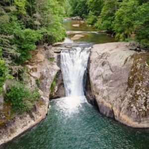
 One of the most underrated Pisgah forest hikes east of Asheville. Catawba Falls sits at the headwaters of the Catawba River — which eventually flows hundreds of miles east through the Piedmont — in a narrow gorge near Old Fort. The 3-mile round-trip trail crosses the river multiple times on footbridges and passes Lower Catawba Falls (100 feet) before reaching the Upper Falls plunge above. Far less visited than the Pisgah and DuPont corridors, and significantly closer to Charlotte than most western NC waterfalls. Easy access from I-40 at Exit 73.
Pisgah Forest Hikes by Difficulty
Quick Reference — Pisgah National Forest Hikes by Difficulty
Easy (under 2 miles, minimal elevation):
Moore Cove Falls — 1.4 mi · Walk-behind waterfall · Pisgah District
Lovers Leap Loop — 1.6 mi · AT hike from Hot Springs · Appalachian District
Graveyard Fields to Lower Falls — 0.6 mi · Blue Ridge Parkway · Pisgah District
Max Patch Short Loop — 1.5 mi · 360° summit views · Appalachian District
Craggy Gardens Pinnacle — 1.4 mi · Rhododendron balds · Toecane District
Moderate (2–6 miles, manageable elevation):
Looking Glass Rock Trail — 6 mi · 1,700 ft gain · Summit views · Pisgah District
Black Balsam Knob — 1.4 mi to summit (longer ridge walks possible) · 6,214 ft · Pisgah District
Graveyard Fields Full Loop — 3.2 mi · Two waterfalls · Pisgah District
Max Patch Full Loop — 2.4 mi · Appalachian District
Catawba Falls — 3 mi · River crossings · Grandfather District
Strenuous (6+ miles or significant technical terrain):
Laurel River Trail — 7.3 mi one way · Best as point-to-point · Appalachian District
Art Loeb Trail full route — 30.1 mi total · Pisgah District
Linville Gorge trails — Variable · Rugged backcountry · Grandfather District
Pisgah Forest Hikes — Practical Tips
Hurricane Helene note: Hurricane Helene hit western NC in September 2024 and caused significant trail damage across multiple districts. Many trails have reopened, but some remain closed or rerouted as of 2026. Always confirm current trail status at fs.usda.gov or by calling the relevant ranger district before visiting. The Pisgah Ranger District office is at (828) 877-3265. The Appalachian Ranger District (Hot Springs) is at (828) 622-3202.
No permits required: Hiking and backpacking in Pisgah National Forest are free and require no permits. Some individual sites charge day-use fees (Sliding Rock, Cradle of Forestry). Dispersed camping is allowed in most areas — check district regulations before setting up.
Dogs: Allowed throughout Pisgah National Forest with few restrictions. Max Patch requires a 6-foot leash maximum. Always check site-specific rules.
Best seasons: Spring (March–May) for wildflowers, waterfalls at peak flow, and AT thru-hiker traffic through the northern district. Fall (mid-September–November) for foliage — Graveyard Fields turns early, Black Balsam and the high balds go quickly. Winter is underrated — Looking Glass freezes, Black Balsam gets snow, and the summit hikes lose 90% of their crowds.
Where to Stay for Pisgah National Forest Hiking
For the southern Pisgah district, Brevard and the Davidson River corridor put you closest to Looking Glass Rock, Black Balsam, and the waterfall hikes on US-276. Davidson River Campground is the Forest Service’s main campground in the Pisgah district.
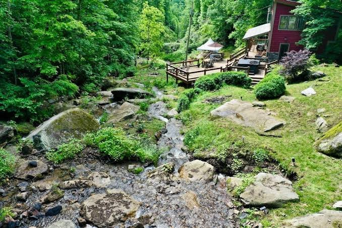
For the northern Appalachian Ranger District — Max Patch, Lovers Leap, the Laurel River Trail, and the AT corridor through Madison County — Windows Over Waterfalls is the natural base camp. A private waterfall cabin 15 minutes from Max Patch and 20 minutes from Hot Springs, on 4 secluded acres in Pisgah National Forest country. Multiple waterfalls run the full length of the property. Hot tub above the creek. 38 windows and skylights. Two fire pits, a 1,600 sq ft deck, and the sound of cascading water through every night. One booking at a time — the whole property is yours. Book direct at windowsoverwaterfalls.com.
For a full breakdown of lodging options in the Hot Springs area — campgrounds, B&Bs, cabins, and glamping — see our Hot Springs NC accommodations guide. For everything to do between hikes — mineral springs, rafting, restaurants — see our Hot Springs NC guide.
Airbnb designates this as a top 10% home — their designation, not ours · Guest Favorite · Superhost
What Airbnb Guests Are Saying
★ 4.97
243 Five-Star Reviews
243 Reasons to Book With Confidence
As of June 2026 — and still growing.
Planning a Wedding or Elopement in Pisgah National Forest?
The same property hosts private waterfall ceremonies through our sister site — all-inclusive elopement packages from $4,400 with photography, florals, officiant, hair & makeup, and more.


