
Asheville NC hiking punches far above its weight for a city of its size. Within an hour’s drive in any direction, you have access to some of the most varied and spectacular trail systems in the eastern United States — the Blue Ridge Parkway threading south through high-elevation balds, Pisgah National Forest spreading across 500,000 acres of hardwood ridges and waterfall gorges, the Appalachian Trail running north through Max Patch and into the Hot Springs corridor, and dozens of lower-key local trails tucked into the mountains immediately surrounding the city. The Blue Ridge Mountains that frame Asheville in every direction aren’t just scenery — they’re one of the most accessible and diverse hiking landscapes in the country.
This guide covers the best Asheville NC hiking — organized by location and difficulty. Blue Ridge Parkway trails, Pisgah National Forest hikes, trails in town, and the best day hikes within an hour’s drive. Whether you have an afternoon or a full week, the mountains around Asheville reward every level of effort.
Asheville NC Hiking — At a Glance
Closest summit hike: Craggy Gardens Pinnacle — 25 miles north on the Blue Ridge Parkway · 5,640 ft · Rhododendron balds
Best Blue Ridge Parkway hike: Black Balsam Knob — 30 miles south · 6,214 ft · 360° views · Easy approach
Most iconic Asheville hike: Mount Pisgah — 2.4 miles round-trip · 5,721 ft summit · Views of Asheville on clear days
Best history hike: Rattlesnake Lodge — 3.9 miles · Blue Ridge Parkway · Ruins of 1904 summer estate
Best waterfall hike from Asheville: Looking Glass Falls + Moore Cove Falls — 40 min south in Pisgah
Best high-elevation bald walk: Black Balsam to Tennent Mountain — 3 miles on open balds above 6,000 ft
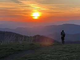
Best AT hike from Asheville: Max Patch — 1 hour north · 4,629 ft · 360° views · Grassy bald summit
No permit required: All trails in this guide are free and permit-free
Hurricane Helene note: Some trails remain affected from 2024 storm damage — confirm status before visiting
Why Asheville NC Hiking Is So Extraordinary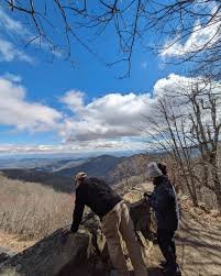
Asheville sits at approximately 2,134 feet elevation in a broad river valley ringed by mountain ranges that top out above 6,000 feet. That geography — a city in a bowl, surrounded by ridgelines — means you can be on a trail with genuine elevation and views within 20–30 minutes of downtown. No long approach drives. No flat warmup miles through suburban sprawl. The mountains start immediately.
The Blue Ridge Parkway is the organizing spine of Asheville NC hiking — a 469-mile road that enters Asheville from the northeast and runs south through some of the most dramatic terrain in the Appalachians. Most of the best day hikes from Asheville are accessed directly from Parkway overlooks or from Pisgah National Forest trailheads just off the Parkway corridor. In practice, this means you can string together three or four excellent hikes in a single day with minimal driving between them.
The other defining feature of Asheville hiking is the elevation. At 6,000 feet, Black Balsam Knob and the high balds south of Asheville feel more like New England than the South — treeless summits, alpine wildflowers, sweeping ridge views. In summer, those summit temperatures run 15–20 degrees cooler than the city below. In fall, the balds turn first. In winter, you can have the trails almost entirely to yourself.
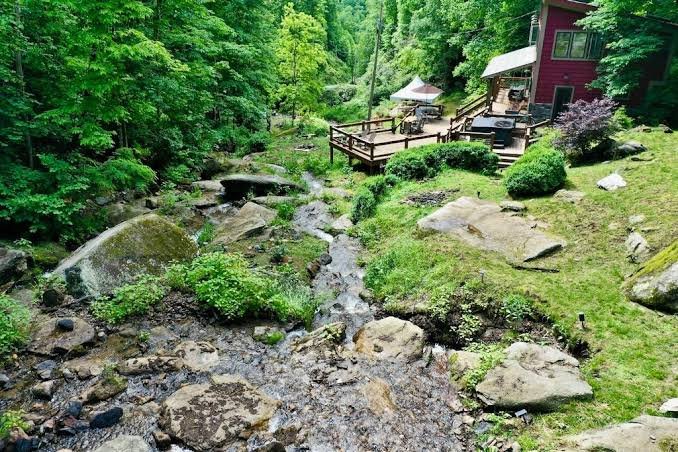
Looking for a private mountain base for your Asheville hiking trip? Windows Over Waterfalls is 1 hour north — private waterfalls, hot tub, 15 min from Max Patch. Check Availability →
Blue Ridge Parkway Hikes Near Asheville — South of Town
The Blue Ridge Parkway south of Asheville offers the most concentrated collection of high-quality day hikes within range of the city. From Asheville’s southern Parkway entrance at NC-191 (near the Biltmore area), you can reach most of these trailheads within 30–45 minutes.
 The best high-elevation hike accessible from Asheville, and one of the most extraordinary landscapes in the southern Appalachians. Black Balsam Knob rises to 6,214 feet — among North Carolina’s forty mountains over 6,000 feet — with a grassy, treeless summit that more closely resembles the White Mountains of New Hampshire than anything you’d expect in the South. The approach from Black Balsam Road (a short spur off the Parkway near MP 420.2) walks through balsam fir forest before breaking into open alpine meadow. Views are 360 degrees from the summit: Graveyard Fields below, the full Parkway ridge to the north, the Smokies on the far western horizon.
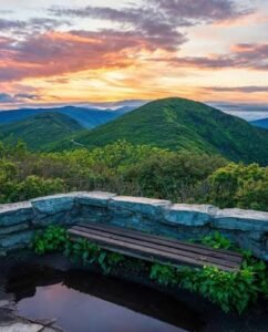
 Mount Pisgah is the mountain Asheville is named for — or rather, the national forest that surrounds the city takes its name from this peak, which in turn was named by early settlers for the biblical mountain from which Moses first saw the Promised Land. At 5,721 feet, it’s visible from downtown Asheville on clear days, from Biltmore Estate, and from most of the northern Blue Ridge Parkway corridor. The summit supports a television transmission tower for the local ABC affiliate — not exactly pristine wilderness, but the 360-degree views from the observation deck are genuine, taking in the Shining Rock Wilderness, Cold Mountain, Looking Glass Rock, and on clear days, Asheville in the valley below.
 One of the most popular and most rewarding hikes within range of Asheville — and the best fall foliage hike in the entire Blue Ridge Parkway corridor near the city. Graveyard Fields sits in a mile-high valley at MP 418.8, named for the moss-covered stumps that resembled grave markers after a catastrophic windstorm toppled the original forest. The open highland meadow, threaded by Yellowstone Prong and ringed by 6,000-foot peaks, is unlike anything else on the Parkway. Two waterfalls on the loop: Lower Falls (55 feet, just 0.3 miles from the parking area) and Upper Falls (1.5 miles in). Wild blueberries peak in August. Fall color arrives here in mid-September — often the first spot in the mountains to turn.
Blue Ridge Parkway Hikes Near Asheville — North of Town
 The most historically layered hike in the Asheville NC hiking repertoire — and one of the most underrated. Rattlesnake Lodge was built in 1903–1904 by Dr. Chase P. Ambler, a prominent Asheville physician and conservationist. Ambler was one of the founders of the movement to establish Great Smoky Mountains National Park, helped lead efforts to pass the Weeks Act of 1911 that eventually created Pisgah National Forest, and was chairman of the committee that founded the Carolina Mountain Club. The lodge’s unusual name came from the 41 rattlesnakes reportedly killed in the first three years the family spent there — their skins hung from the living room ceiling. Mrs. Ambler died in 1918; the doctor never returned, sold the property, and the lodge burned in 1926.
Base camp for northern Asheville hiking — Windows Over Waterfalls is 1 hour away with private waterfalls and 15-minute access to Max Patch. Book Direct →
Pisgah National Forest Hikes from Asheville
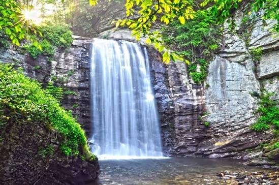
Pisgah National Forest’s Pisgah Ranger District sits 35–50 miles south of Asheville — 45–55 minutes down US-276 from Brevard. This is the waterfall district: Looking Glass Falls, Sliding Rock, Moore Cove Falls, and a dozen others along the Forest Heritage Scenic Byway. For the full rundown of every Pisgah forest hike by district, see our complete Pisgah forest hikes guide. The highlights for Asheville day trippers:
The Best AT Day Hike from Asheville — Max Patch
Asheville NC Hiking by Difficulty
Quick Reference — Asheville Area Hikes by Difficulty
Easy (under 2 miles, accessible to most hikers):
Craggy Gardens Pinnacle — 1.4 mi · 25 miles north · 5,640 ft · Rhododendron display
Black Balsam Knob short approach — 1.4 mi · 30 miles south · 6,214 ft · Alpine balds
Graveyard Fields to Lower Falls — 0.6 mi · 27 miles south · Two falls, restrooms
Max Patch Short Loop — 1.5 mi · 1 hour north · 360° AT summit views
Moderate (2–5 miles, manageable elevation):
Mount Pisgah — 2.4 mi · 700 ft gain · Asheville’s signature mountain
Graveyard Fields Full Loop — 3.2 mi · Two waterfalls · Best fall colors
Rattlesnake Lodge — 3.9 mi · 882 ft gain · History + forest ruins
Max Patch Full Loop — 2.4 mi · Open ridge walking
Looking Glass Rock — 6 mi · 1,700 ft gain · Granite summit views
Strenuous (6+ miles or significant elevation):
Looking Glass Rock full summit — 6 mi · 1,700 ft · Best Pisgah summit hike
Black Balsam to Tennent to Sam Knob ridge walk — 5+ mi · All above 6,000 ft
AT from Lemon Gap to Max Patch — 5.1 mi round-trip · Backcountry approach
Seasonal Guide to Asheville NC Hiking
Spring (March–May): Wildflowers are the story — trout lily, trillium, wild geranium, and serviceberry bloom in sequence from the valley floor to the high balds. Waterfalls run at their highest volume. The AT sees peak northbound thru-hiker traffic in April and May, especially through the Hot Springs and Max Patch corridor north of Asheville. Mud can be an issue on high-elevation trails in early spring.
Summer (June–August): The catawba rhododendron display at Craggy Gardens peaks in mid-to-late June — one of the most extraordinary natural events in the Asheville hiking calendar. Black Balsam and the high balds wildflower peak follows in July and August. Temperatures at 6,000 feet run 15–20 degrees cooler than the city. Afternoon thunderstorms are common — be off exposed summits by early afternoon. Parking at popular trailheads fills by 9–10am on summer weekends.
Fall (mid-September–November): The peak season for Asheville NC hiking — and the most crowded. Graveyard Fields turns first (mid-September), then the high balds, then the lower elevations through October. Foliage framing the waterfall hikes in Pisgah is exceptional in mid-to-late October. Clear days produce the farthest-reaching views of the year. Book any lodging near the mountains well in advance for October weekends.
Winter (December–March): The most underrated season. Looking Glass Falls partially or fully freezes. Black Balsam gets snow. Max Patch becomes a silent white expanse. Crowds drop dramatically. The Parkway closes in sections during ice events — check nps.gov/blri before going. All-wheel drive or chains recommended for high-elevation trailheads. Layers and traction devices (microspikes) are essential for icy summit terrain.
Where to Stay for Asheville NC Hiking
Asheville itself has no shortage of hotels, vacation rentals, and B&Bs — and staying in town puts you close to the southern Parkway trailheads and Pisgah. For the northern corridor hikes — Max Patch, the AT through Hot Springs, the Laurel River Trail, and Craggy Gardens — staying north of Asheville cuts the drive time significantly and puts you in a different quality of mountain experience.
Windows Over Waterfalls is a private waterfall cabin one hour north of Asheville in the mountains above Hot Springs — 15 minutes from Max Patch, 20 minutes from the Hot Springs AT trailhead and mineral springs. Four secluded acres with multiple waterfalls running the full length of the property, a hot tub above the creek, 38 windows and skylights, two fire pits, and the sound of cascading water through every night. One booking at a time. The whole property is yours. Book direct at windowsoverwaterfalls.com — no platform fees.
After a day of Asheville NC hiking, the natural recovery move in this part of the mountains is the Hot Springs Resort and Spa — private mineral spring soaking tubs at 102–103°F on the banks of the French Broad River, 20 minutes from the property. For everything to do in the Hot Springs area between hikes, see our Hot Springs NC guide.
Airbnb designates this as a top 10% home — their designation, not ours · Guest Favorite · Superhost
What Airbnb Guests Are Saying
★ 4.97
243 Five-Star Reviews
243 Reasons to Book With Confidence
As of June 2026 — and still growing.
Planning a Wedding or Elopement in the Asheville Mountains?
The same property hosts private waterfall ceremonies through our sister site — all-inclusive elopement packages from $4,400 with photography, florals, officiant, hair & makeup, and more.


