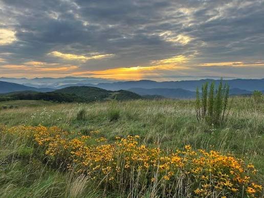
There are mountains you hike to see the view. And then there’s Max Patch Mountain NC — where the mountain itself is the view. A 4,629-foot grassy bald in the Pisgah National Forest on the North Carolina-Tennessee border, Max Patch sits on the Appalachian Trail with nothing above it but sky. No trees at the summit. No obstructions in any direction. Just an open meadow rolling across a mountaintop with 360-degree panoramas stretching to the Great Smoky Mountains in the west, Mount Mitchell in the east, the Black Mountains to the south, and the Bald Mountains of Tennessee to the north. On a clear day, you can see across five states.
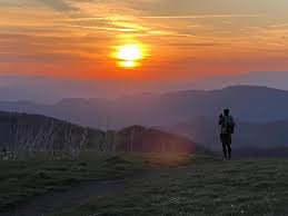
Most people who visit Max Patch describe the same thing: standing at the summit and going quiet. Not from exhaustion — the hike is short. From scale. The southern Appalachians unfold in every direction like a slow-moving green ocean, ridge after ridge fading into haze, with the AT white blazes threading across the grass beneath your feet and thru-hikers moving through like they’ve been doing since 1948. It is, without much argument, the single most visually stunning moment available within an hour of Asheville.
Max Patch Mountain NC — At a Glance
Elevation: 4,629 ft
Location: Madison County, NC · Pisgah National Forest · NC-Tennessee border
Distance from Hot Springs NC: 15 minutes (7.3 miles via Hwy 209 then forest roads)
Distance from Asheville: 1 hour to 1 hour 15 min (47 miles)
Trail: Max Patch Loop — 1.5 miles (short loop) or 2.4 miles (full loop)
Difficulty: Easy to moderate — gentle grade, no technical terrain
Views: 360-degree panoramic — Smokies, Mount Mitchell, Black Mountains, Bald Mountains
Fees: None · No permit required (as of 2026 — confirm before visiting)
Camping: Prohibited on the summit — closed July 2021 due to environmental damage
Fires: Prohibited
Dogs: Allowed on leash (6 ft max)
Hours: Opens 1 hour before sunrise · Closes 1 hour after sunset
Group size: Maximum 10 people
Parking: Parking: Small lot — approximately 11 cars · Roadside parking along Max Patch Rd common on busy days · Do not block emergency access
Restrooms: None on site · Nearest 20 minutes away at Harmon Den Horse Camp
Ranger contact: Appalachian Ranger District · (828) 689-9694 · appalachianrd@usda.gov
The History of Max Patch — From Cattle Pasture to Icon

Max Patch Mountain NC looks like it was always meant to be an open summit — but that’s not how it started. The bald was created by human hands in the 19th century, when Appalachian farmers cleared the forest from the mountaintop to create a high-altitude grazing pasture for cattle and sheep. The animals would be driven up the mountain each summer and brought back down before winter. The treeline never returned because the clearing was maintained — and later, because the U.S. Forest Service took over that management role.
In the 1920s and 1930s, the open meadow found a second life as a makeshift airstrip. At that elevation, the bald was said to be one of the highest airstrips in the eastern United States. Local accounts describe biplane air shows that drew thousands of people to the summit — a remarkable detail for what was then a remote mountain in Madison County. The inn that operated in the area during this period served as part of a hostel circuit for early Appalachian travelers.
The property remained in private hands until 1982, when the U.S. Forest Service purchased 350 acres specifically to prevent a developer’s plan to build a ski resort on the summit. It was one of the more quietly consequential conservation purchases in western NC history — the bald you stand on today was nearly a ski run. The Appalachian Trail was rerouted to cross the summit after the purchase, and volunteers from the Carolina Mountain Club relocated the trail from its original position four miles away. Before that rerouting, hikers could only see Max Patch from a distance.
The Trail — What to Expect at Max Patch Mountain NC
The trail system at Max Patch is simple and accessible. Most visitors hike the loop from the parking area — you can do it in either direction.
Short Loop (1.5 miles): The classic Max Patch experience. From the parking area, the trail heads into forest briefly before breaking open onto the summit meadow. You follow white AT blazes and wooden marker posts across the grass to the summit, with the views expanding with every step. Elevation gain is gentle throughout — this is one of the most accessible summit experiences in the southern Appalachians. Round-trip time for most hikers is 45 minutes to an hour, not counting summit time.
Full Loop (2.4 miles): The longer version circles the full perimeter of Max Patch, combining the open summit traverse with a wooded section along the north face before returning to the parking area. Adds about 45 minutes and gives you more of the forested transition zone. Recommended if you have time.
Lemon Gap to Max Patch (AT approach, 5.1 miles round-trip): For those wanting a longer backcountry approach, the Appalachian Trail from Lemon Gap covers creek-filled valleys and forested ridgeline before emerging onto the bald. Moderate difficulty, significant more elevation gain. The reward is arriving at the summit the way thru-hikers do — from the forest, on foot, with the bald appearing suddenly above you.
Staying near Max Patch? Windows Over Waterfalls is 15 minutes away — private waterfalls, hot tub above the creek, and the whole property to yourself. Check Availability →
The Views — What You Actually See from the Summit
The 360-degree panorama from Max Patch Mountain NC is the reason the summit has become one of the most recognized landmarks on the entire 2,190-mile Appalachian Trail. On a clear day:
West: The Great Smoky Mountains — the full ridge of the Smokies stretches across the horizon, with Clingmans Dome visible as the highest point.
East: Mount Mitchell — at 6,684 feet the highest peak in the eastern United States, visible on the far horizon on clear days as the dark mass rising above the Black Mountain range.
North: The Bald Mountains of Tennessee — the ridgeline the AT follows north toward Hot Springs and beyond, into Virginia.
South: The layered ridges of Pisgah National Forest and the Plott Balsams.
What photographs don’t fully capture is the openness. At summit level on Max Patch, there is nothing between you and the horizon in any direction. No trees. No ridge blocking part of the view. The entire sky is yours. Hikers consistently describe it as one of the only places in the mountains where they felt genuinely, completely surrounded by landscape rather than enclosed by it.
Best Times to Visit Max Patch Mountain NC
Max Patch is worth visiting in every season, but the experience changes dramatically based on when you go. Here’s what each season actually delivers:
Spring (April–May): Wildflowers bloom across the summit meadow — wild blueberries, blackberries, and native grasses push through after winter. The AT sees its peak northbound thru-hiker traffic in April and May, with hundreds of through-hikers crossing the summit each week. Water from winter snowmelt keeps the surrounding creeks full. The views on clear days are at their sharpest before summer haze builds. Mud can be an issue on the approach roads in early spring.
Summer (June–August): Peak visitor season — the small parking lot fills fast, and on busy summer weekends both sides of Max Patch Road fill with cars parked along the roadside for a quarter mile in each direction. Technically discouraged, practically unavoidable on peak days. Arrive before 8am if you want the lot. Weekday mornings are dramatically quieter. Temperatures at the summit run 10–15 degrees cooler than in Asheville or Hot Springs. Afternoon thunderstorms are common July through August; the exposed summit has zero shelter from lightning. Check the forecast and be off the bald before storms build. Wildflowers peak in late June and July.
Fall (mid-September–November): The best all-around season for Max Patch. Foliage color begins at the highest elevations in mid-September and works down to the valley floor by late October. The summit grass turns amber and gold, the surrounding ridges go crimson, and the air clarity at this time of year produces the sharpest, farthest-reaching views of the year. Crowds are significant on October weekends but manageable on weekdays. This is when most photographers plan their Max Patch visits.
Winter (December–March): The most underrated season. Snow transforms Max Patch into a silent, white expanse with ice-crusted grass and dramatically clear views — the haze that builds in summer is completely gone, and you can see farther on a cold February morning than at any other time of year. Ice and snow on the approach road require 4WD or AWD and chains in heavy conditions. Check road conditions before making the drive. The parking lot holds only 11 cars and often fills even in winter on sunny weekend days. Worth every bit of the effort.
The Overcrowding Problem — and How Max Patch Came Back
Max Patch Mountain NC’s story over the past decade is also a cautionary tale about what happens when a beautiful place gets too popular too fast — and a success story about what dedicated conservation can accomplish.
By the late 2010s, Max Patch was in serious trouble. Social media exposure drove visitation to levels the fragile summit ecosystem couldn’t handle. Hikers created dozens of unofficial use trails by walking off the designated path, destroying native vegetation. Camping — once permitted — led to illegal campfires on the exposed, wind-swept summit, a genuine wildfire risk to the surrounding Spring Creek community. Carolina Mountain Club volunteers were hauling truckloads of trash off the trail every weekend. The summit that had been maintained as a healthy grassy bald for over a century was becoming an eyesore, with bare soil and scarred vegetation where meadow should have been.
The U.S. Forest Service, the Appalachian Trail Conservancy, and the Carolina Mountain Club responded with significant restrictions: camping was closed permanently in July 2021, fires were prohibited, group sizes were capped at 10, hours were set to close 1 hour after sunset, and the parking area was capped at 11 vehicles with no road parking permitted when the lot is full.
The restoration has worked. By 2023, reviewers on hiking sites were noting the return of healthy grasslands, buzzing pollinators, and bird activity that had been absent during the peak overuse years. The golden-winged warbler — a species of conservation concern — has returned to nest on the mountain. The meadow is coming back. The restrictions that frustrated some visitors in the short term saved the place that everyone came to see.
Current Rules at Max Patch (Follow These)
Max Patch Rules — U.S. Forest Service (Current as of 2026)
No camping — summit closure permanent as of July 2021
No fires or fireworks — wind conditions make this a serious wildfire risk
Hours: Opens 1 hour before sunrise · Closes 1 hour after sunset
Group size: Maximum 10 people
Dogs: Leash required · Max 6-foot leash · No exceptions
Stay on designated trails — off-trail walking destroyed the summit; restoration is ongoing
No drones — prohibited on the Appalachian Trail
No bikes — bikes must stay on roads only
No horses or pack animals
Parking: ~11 cars in the lot · Road parking not permitted when lot is full · Do not block emergency access
No restrooms or trash cans — pack out everything you bring in
No permits or fees as of 2026 — confirm current status at fs.usda.gov before visiting
How to Get to Max Patch Mountain NC
Max Patch requires navigating forest roads — do not rely solely on GPS, which sometimes routes vehicles down unmaintained or impassable tracks. Use these verified directions:
From Hot Springs NC (35 minutes — the closest approach):
From downtown Hot Springs, head south on Bridge Street until it becomes Highway 209. Follow Hwy 209 for 7.3 miles to Meadow Fork Road (State Road 1175) — there will be a sign; turn right here. Go 5.3 miles and turn right on State Road 1181. Follow 1181 for approximately 2 miles (road turns to gravel). At the top of the mountain turn right onto State Road 1182 — Max Patch parking lot is 1.5 miles on the right.
From Asheville via I-40 (1 hour 20 minutes):
Take I-240 W to US-19 S/US-23 S, then turn right onto NC-63 W and follow it 26.9 miles through Leicester and Marshall. Turn right onto NC-209 N for 1.7 miles, then turn onto Little Creek Road and follow the signs up the mountain to SR-1182. The Max Patch parking area will be on your right. The final miles are unpaved — AWD recommended; 4WD in winter or wet conditions.
From Asheville via Hot Springs (1 hour 15 min — more scenic):
Take US-25/70 north from Asheville 36 miles into Hot Springs, then follow the Hot Springs directions above.
From Lake Junaluska via NC-209 (scenic mountain route):
Exit I-40 at Exit 24 and follow NC-209 North approximately 8 miles to Fines Creek General Store. Continue straight approximately 12 miles onto Max Patch Road — the last 8 miles are unpaved and curvy. Parking area will be on your left.
Key warnings: No restrooms at the trailhead — nearest facilities are 20 minutes away at Harmon Den Horse Camp. Download offline maps before leaving cell service. The parking lot fills quickly on fall weekends and summer mornings — arrive before 8am or plan to turn around.
Wildlife at Max Patch — What to Know
The summit meadow and surrounding forest support a range of wildlife. Bears are present throughout the Madison County mountains and have been reported near Max Patch, particularly in late summer when berry production peaks. Make noise on the trail, store food properly, and do not leave any food or trash at the summit. Bear spray is widely recommended by regular visitors.
The golden-winged warbler — a small, striking songbird with a yellow crown and black-and-white face pattern — nests on the bald and is one of the conservation targets driving the restoration effort. Keep to the trail to protect nesting habitat. Appalachian cottontails are frequently visible at dawn and dusk in the summit meadow. Raptors use the ridge thermals throughout the day.
Snakes are present on and around the summit, including timber rattlesnakes. Watch where you step, especially in rocky areas along the approach trail. Stay on the path.
Where to Stay Near Max Patch Mountain NC
Most day hikers approach Max Patch from Asheville — but staying near the mountain changes the experience entirely. You can hike at sunrise without a two-hour round-trip drive. You can soak at the Hot Springs mineral springs in the evening after the trail. You can wake up to a second morning on the summit when the parking lot is empty.
The closest lodging to Max Patch Mountain NC is in and around Hot Springs — just 15 minutes from the trailhead. For a full breakdown of every accommodation option including campgrounds, B&Bs, and cabins, see our Hot Springs NC accommodations guide.
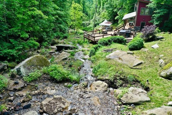
For couples and small groups wanting complete privacy, Windows Over Waterfalls is a private waterfall cabin 15 minutes from Max Patch on 4 secluded acres in the mountains above Hot Springs. Multiple waterfalls run the full length of the property. A hot tub sits above the creek. 38 windows and skylights bring the forest inside. Two fire pits, a 1,600 sq ft deck, and the sound of cascading water through the night. One booking at a time — the whole property is yours. Book direct at windowsoverwaterfalls.com.
After the hike, the natural next stop is the Hot Springs Resort and Spa — 20 minutes from Max Patch, with private mineral spring soaking tubs at 102–103°F on the banks of the French Broad River. The combination of a Max Patch sunrise hike and an afternoon mineral soak is the most-recommended two-part itinerary in Madison County for good reason.
Airbnb designates this as a top 10% home — their designation, not ours · Guest Favorite · Superhost
What Airbnb Guests Are Saying
★ 4.97
243 Five-Star Reviews
243 Reasons to Book With Confidence
As of June 2026 — and still growing.
15 minutes from Max Patch. Private waterfalls. The whole property to yourself. Book Direct →
Max Patch and the Appalachian Trail
The Appalachian Trail crosses the summit of Max Patch running north to south — one of the few points on the entire 2,190-mile trail where the path breaks fully into open sky for an extended stretch. For northbound thru-hikers, Max Patch typically falls around the 275-mile mark from Springer Mountain in Georgia — a major early morale booster, often described in trail journals as the moment the hiking feels worth it. For southbound hikers approaching from Maine, it marks the beginning of the most rugged section of the southern Appalachians.
The trail enters from the south through Pisgah National Forest and exits north toward Lemon Gap, with the descent from Max Patch toward Hot Springs being one of the most beloved short sections of trail in the South. Hot Springs itself — 15 minutes from Max Patch by car, several hours on foot — is one of the only trail towns in North Carolina where the AT runs directly through downtown. Thru-hikers who camp at the Hot Springs Resort campground and soak at the mineral springs before continuing north have been doing so since the trail was established through this section in the late 1940s.
For everything to do in Hot Springs while you’re in the area — including the AT trailhead, mineral springs, restaurants, and river outfitters — see our complete Hot Springs NC guide.
Planning a Wedding or Elopement Near Max Patch?
The same property hosts private waterfall ceremonies through our sister site — all-inclusive elopement packages from $4,400 with photography, florals, officiant, hair & makeup, and more.


